The Great Trigonometrical Survey of India begins
“From 10 April 1802, when Lambton began measuring a baseline at Madras, a chain of triangles grew across India: the Great Arc, the height of Peak XV (29,002 ft, named Everest in 1856), all by about 1880.”
In 1799 the East India Company beat Tipu Sultan and gained a great deal of new land in southern India, but it had no accurate map of it. Distances on the best maps could be wrong by tens of miles. A British infantry officer, William Lambton, offered a cure. He proposed to measure one line on the ground with great care, then use angles to build a chain of triangles outward from it, so that every point on the map could be calculated and not just sketched. The Government of Madras agreed in February 1800. On 10 April 1802 Lambton began to measure a baseline on flat ground just east of St Thomas Mount, near Madras, with a steel chain; he finished on 22 May. That line, about seven and a half miles long, was the first step of what became the Great Trigonometrical Survey.
Lambton's method was triangulation. Once a baseline is known, a surveyor with a large theodolite measures the angles to a far-off hill from each end, and the rest follows by trigonometry. Each hill then becomes the corner of the next triangle. Lambton's theodolite was made in London by William Cary as a copy of Jesse Ramsden's famous instrument for the Ordnance Survey; it had a circle three feet across, weighed over 1,000 pounds packed, and needed about a dozen porters. On its way out it was captured, according to George Everest, by the French frigate Piémontaise and then forwarded by the French with a polite letter. In 1806 his triangles joined the east coast to the west coast and showed that the peninsula was 360 miles wide, not the 400 that the maps gave. Lambton went on to build a line of triangles running north and south, the Great Arc, to measure the shape of the Earth as well. In 1808 the theodolite was nearly wrecked when a rope broke as it was hauled up a pagoda at Tanjore. Lambton had it repaired and carried on. From 1 January 1818 the work was a project of the Government of India, with the name Great Trigonometrical Survey; he died on the road to Nagpur on 20 January 1823, at about 70.
George Everest, his assistant and successor, turned the survey into a modern geodetic one. He was Surveyor General of India and head of the Survey from October 1830 to December 1843. After years in England ordering better instruments, he measured bases with compensation bars that cancel the effect of heat, and he built brick towers for observing across the flat plains of the Ganges. He also set up workshops, and trained Indian instrument makers and mathematicians. One of them was the young Bengali mathematician Radhanath Sikdar, who joined the computing office in December 1831. The field work of Everest's two sections of the Great Arc, from Bidar to the Himalayan foothills at Banog, was finished in December 1841; the whole arc, from near Cape Comorin to Dehra Dun, ran through about 22 degrees of latitude. His successor Andrew Waugh then used the same method to fix the position and height of the Himalayan peaks, observed from stations on the plains of Bihar.
The best-known result came in 1856. Peak XV, observed from six stations between 27 November 1849 and 17 January 1850, was computed at 29,002 feet. On 1 March 1856 Waugh wrote that it was probably the highest mountain in the world and that, as he could find no local name, he would call it Mount Everest. The name was challenged at once: B. H. Hodgson, who lived in Darjeeling, argued that Nepalis called it Devadhunga. Waugh stood by his choice, and at the Royal Geographical Society in 1857 the President hoped the mountain would always be known in England as Everest. The credit for the computation is also disputed: a popular story gives it to Sikdar, but the published record does not show it, and Waugh's own letter thanks a different officer, J. Hennessey, for his help in revising the computations. After 1861 the Survey was led by James Walker. It also trained 'pundits', Indian explorers who measured Tibet by counting paces: Nain Singh reached Lhasa on 10 January 1866 and returned through Assam in 1874–75. In 1878 the Survey was merged with the topographical and revenue surveys into the Survey of India, and its last principal triangulation was finished in the 1879–80 season.
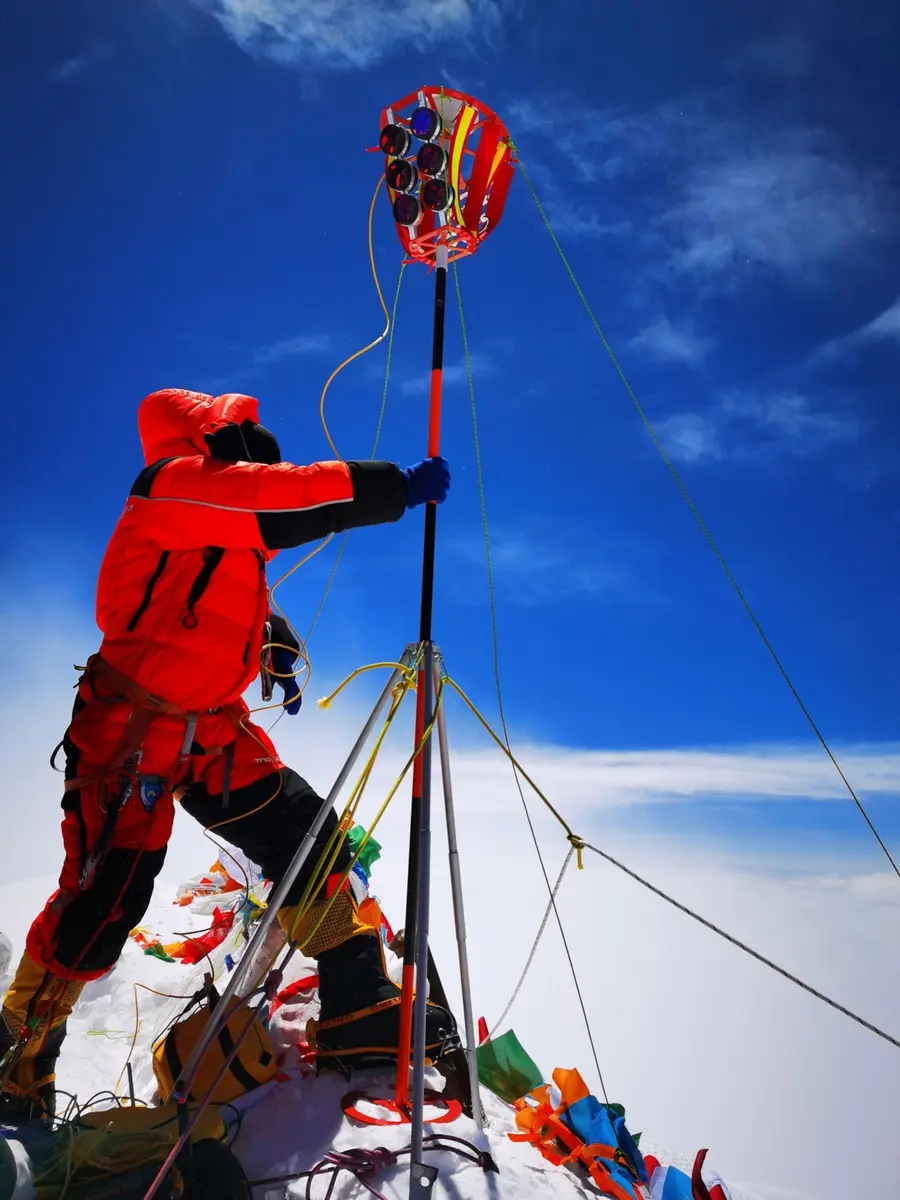
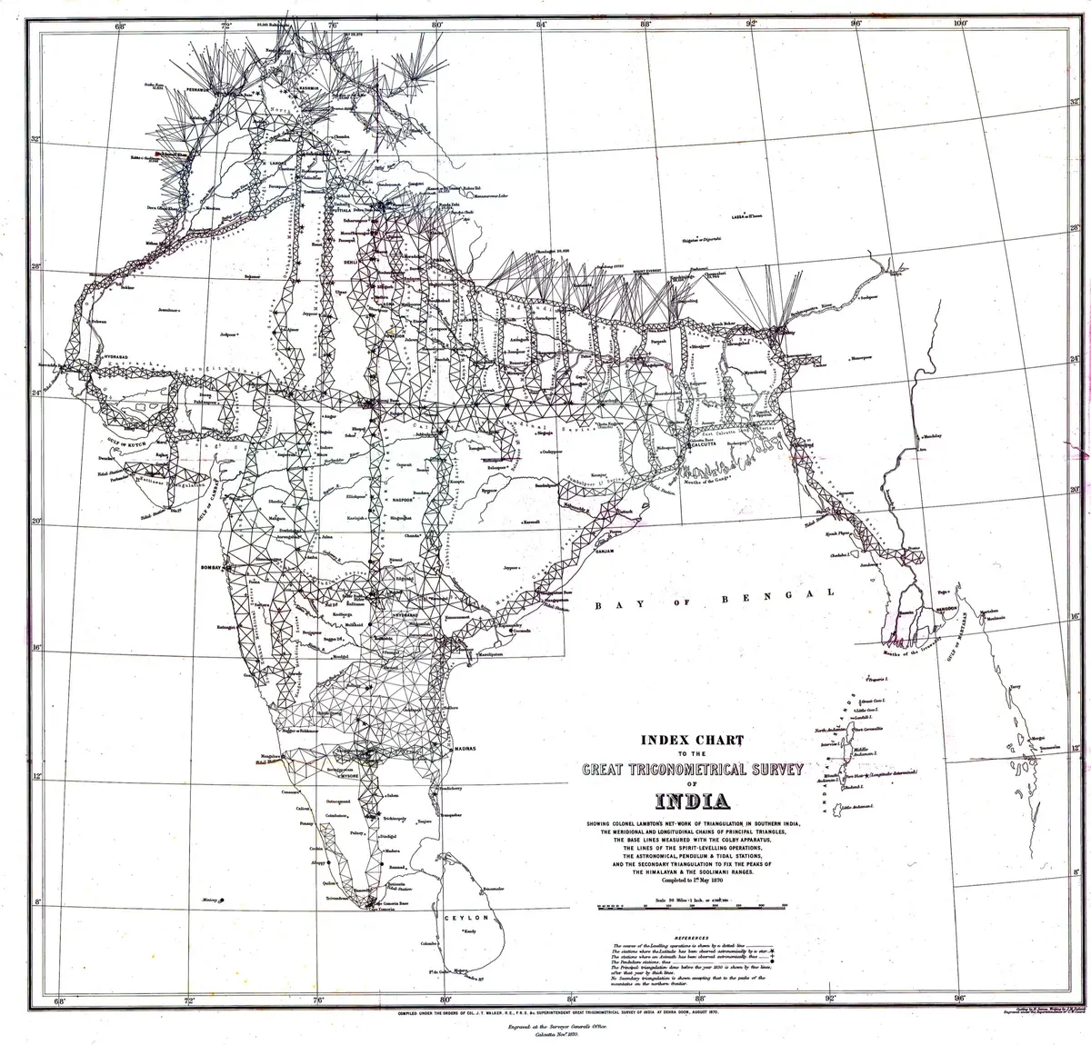
The Survey gave India its first accurate frame of fixed points, and it shaped everything built on top of it: provincial maps, railways, canals and borders. Its chart of 1870 still looks like a great grid laid over the whole country. It was also an instrument of empire, designed to make the land legible to the Company and the Crown, and the work was done by thousands of Indian surveyors, porters and computers, many of whom died of fever. In one season on the Himalayan series forty men died. Their names were mostly left out of the record, as Sikdar's role shows. The mountain it named has been measured again many times, most recently by China and Nepal in 2020.
What happened
- 1802
Near Madras, on the flat ground just east of St Thomas Mount, William Lambton begins to measure a baseline with a steel chain. It is the first operation of his general trigonometrical survey. He uses the new chain just sent out from England as a standard, and compares it with his working chain before and after the measurement.
St Thomas Mount, Madras (Chennai), where Lambton measured the first baseline in 1802The Madras baseline is finished. Markham gives it as seven and a half miles long. Lambton also observes the angle the line makes with the meridian, because the same line serves for a degree of latitude and for his triangles across the peninsula.
St Thomas Mount, Madras (Chennai), where Lambton measured the first baseline in 1802The Great Theodolite, built in London by William Cary as a copy of Ramsden's, reaches Lambton, and at the end of September he starts his triangles, with John Warren as assistant. According to Everest it was taken by a French frigate on the voyage out and sent on by the French with a courtesy letter. Some accounts put its arrival in Madras in 1801.
St Thomas Mount, Madras (Chennai), where Lambton measured the first baseline in 1802- 1803
Lambton and Warren carry triangles south to Cuddalore and fix both ends of a meridian arc by the stars; Lambton observes Aldebaran on 16 nights at each end with Ramsden's zenith sector, to give the length of a degree of latitude. (Phillimore puts the westward start twelve months after September 1802, so the arc falls between; the year is a best placement.)
- 1806
Lambton's triangles reach the west coast at Tellicherry, Cannanore and Mount Delly, joining the two seas. They show the peninsula to be 360 miles wide at that latitude, not the 400 of the best maps: forty miles taken off at a stroke. Phillimore says the triangles reached the coast in 1805; Markham says the work was completed in 1806.
- 1808
At Tanjore, after measuring a baseline in four days in July, Lambton's party hoists the Great Theodolite up a pagoda. A rope gives way, the instrument strikes the wall, and its circle is bent. By Everest's account Lambton has it restored in about six months, at the workshops at Bangalore.
Thanjavur (Tanjore), where the Great Theodolite was damaged on a pagoda in 1808 - 1809
Lambton takes the Great Arc as far south as Punnae near Cape Comorin and is caught up in the war with Travancore for some weeks, then released. This is the southern end of the line he and Everest will extend 22 degrees north.
Kanniyakumari (Cape Comorin), the southern end of the Great Arc- 1818
The Government of India takes over the survey from Madras and names it the Great Trigonometrical Survey, with Lambton as superintendent, George Everest as chief assistant and a surgeon-geologist. The despatch from Lord Moira (the Marquess of Hastings) is dated 25 October 1817.
- 1823
Lambton dies at Hinganghat, five marches short of Nagpur, on his way to move his headquarters north. He is about 70 and has long been ill with tuberculosis. Everest, who had been sent west towards Poona, takes charge and goes on with the Great Arc.
Hinganghat, where Lambton died on 20 January 1823- 1824
Everest measures a base at Sironj with the old chain. It becomes the most important base in the survey, because the work to the north, east and west depends on it. In January 1825 his health breaks down.
Sironj, the base of the Great Arc and the start of the Calcutta longitudinal series- 1826
Everest is in England on sick leave until 1830. He studies the newest instruments, has a large theodolite and two vertical circles built by Troughton and Simms, and tests compensation bars at Lord's cricket ground. Markham puts his departure in 1826; Phillimore says 1825.
- 1830
Everest takes office in Calcutta as Surveyor General of India and Superintendent of the Great Trigonometrical Survey, two jobs in one. He brings six sets of compensation bars and the best instruments of the day.
Kolkata (Calcutta), the Surveyor General's office and the Asiatic Society of Bengal- 1831
Everest begins to measure the Calcutta base line along the road to Barrackpore, the first in India measured with compensation bars. The Madras astronomer Taylor comes to help. Two towers, 76 feet high, mark its ends.
Sukchar tower, the northern end of the Calcutta (Barrackpore) base line, 1831-32A student of about 18 from the Hindu College, Radhanath Sikdar, joins the survey's computing office. Everest soon takes him under his wing, and later says his mathematics would rank very high even in Europe. Accounts give his appointment as 19 or 20 December.
Kolkata (Calcutta), the Surveyor General's office and the Asiatic Society of Bengal- 1832
The Calcutta base is finished. On 2 July 1832 the triangulation of the Calcutta longitudinal series, running east from Sironj, is complete.
Sukchar tower, the northern end of the Calcutta (Barrackpore) base line, 1831-32- 1834
Everest begins to measure the Dehra Dun base, the northern base of the Great Arc, in the Doon valley, with compensation bars. His headquarters are at Hathipaon above Mussoorie. Waugh and Renny measure it again in reverse order.
Dehra Dun, where the Great Arc's northern base was measured in 1834-36- 1836
The measuring of the Dehra Dun base is done: 7.42 miles. The two measurements differ by 2.4 inches. The base is carried by triangles to the Siwalik peaks of Amsot and Banog.
Dehra Dun, where the Great Arc's northern base was measured in 1834-36- 1839
At Kalianpur and Kaliana, 48 nights of simultaneous star observations begin with two three-foot circles by Troughton and Simms, which the instrument maker Mohsin Husain has divided at Mussoorie under Everest's eye. Waugh observes at Kalianpur and Everest at Kaliana. The aim is to measure the arc between them by the stars.
Park House, Mussoorie, Everest's hill headquarters and instrument workshop- 1841
Waugh finishes measuring the base at Bidar, completing all the field work of Everest's two sections of the Great Arc, from Bidar (latitude 17 deg 55 min) to Banog in the Himalaya (30 deg 29 min), a direct distance of about 870 miles. Black's memoir of 1891 dates the northern sections to 1840.
Bidar, where Waugh measured the base that completed Everest's field work in 1841- 1843
Everest, who closed his Dehra Dun office in September and handed over to Waugh in Calcutta, sails for England. Andrew Waugh, who has served under him for eleven years, becomes Surveyor General and Superintendent.
Kolkata (Calcutta), the Surveyor General's office and the Asiatic Society of Bengal- 1847
Waugh's observations from the eastern end of the survey show Kangchenjunga to be much higher than Dhaulagiri, which had been supposed the highest mountain in the world. He writes later that his operation of 1847 proved it.
- 1849
The first of six observations of Peak XV is made, from stations on the plain of Bihar; the last is on 17 January 1850. Each gives a height between 28,990 and 29,026 feet, and the mean is 29,002.
Mount Everest (Peak XV)- 1856
At Dehra Dun, Waugh writes his letter No. 29: Peak XV is most probably the highest mountain in the world, it has no local name that he can find, and he will call it Mont Everest. He gives its position as 27 deg 59 min 16.7 sec N, 86 deg 58 min 5.9 sec E, and its height as 29,002 feet.
Dehra Dun, where the Great Arc's northern base was measured in 1834-36At a meeting of the Asiatic Society of Bengal in Calcutta, Henry Thuillier makes the results public in an address.
Kolkata (Calcutta), the Surveyor General's office and the Asiatic Society of BengalFrom Darjeeling, Brian Houghton Hodgson, who has served as a political officer in Nepal, writes that he agrees with using native names but that this mountain has one already, Devadhunga, which he translates 'Holy hill'. He later argues it in the Asiatic Society's Journal.
Darjeeling, where Hodgson lived and wrote about the name Everest in 1856- 1857
At the Royal Geographical Society in London, Waugh's letter and Hodgson's are read. The President hopes that whatever the mountain is called in India, it will always be Everest in England. Everest, present, objects politely that his name cannot be written in Persian or Hindi and that hill people would turn it into 'Ob'ron'.
London, where the Royal Geographical Society met in 1857The Royal Geographical Society gives its Gold Medal to Waugh at its anniversary meeting, for extending the Great Trigonometrical Survey through Rajputana, the Punjab and the Himalaya. The President's address tells the story of the Survey from Lambton on and names Everest.
London, where the Royal Geographical Society met in 1857- 1858
Waugh's paper 'On Mounts Everest and Deodanga', written at Dehra Dun on 5 August 1857, is read at the Royal Geographical Society. He rejects Hodgson's claim that Everest and Deodanga are the same mountain and says he has referred the matter to a committee of officers.
London, where the Royal Geographical Society met in 1857- 1861
Waugh retires, and James Thomas Walker takes over as Superintendent of the Great Trigonometrical Survey. A group photograph of Waugh, Walker, Thuillier and Montgomerie is taken in Calcutta that month.
Kolkata (Calcutta), the Surveyor General's office and the Asiatic Society of Bengal- 1864
Colonel Walker engages two men from a Himalayan valley to be trained under Captain Montgomerie as route surveyors for Tibet, where a European would be in danger. They learn to pace distances, take compass bearings and measure latitude with a sextant, but are deliberately not taught to reduce their observations, so that they cannot invent them. One of them is Nain Singh.
- 1866
After a failed first attempt from Nepal in 1865, the pundit Nain Singh, disguised as the companion of a merchant from Ladakh, reaches Lhasa. Markham gives the arrival as the 10th of January, in the winter of 1865-66.
Lhasa, reached by the pundit Nain Singh on 10 January 1866Sir George Everest dies in London, aged 76.
- 1870
The survey's Index Chart is completed to this date: Lambton's net of triangles, the chains of principal triangles, the base lines, the levelling and the rays to the Himalayan peaks, compiled by Walker at Dehra Dun in August and engraved at Calcutta in November.
- 1875
After a long journey across Great Tibet from Leh to Lhasa and on through Tawang, Nain Singh, now the Survey's chief pundit, is back in India, in Assam. Black dates the return by the Tawang route to 1874-75; the journey is usually dated 1873-75. The Royal Geographical Society prints his account in 1877 with a route map.
- 1878
On the retirement of Thuillier, Walker becomes Surveyor General and head of the topographical branch as well as of the Great Trigonometrical Survey, and the three branches (trigonometrical, topographical, revenue) are merged as the Survey of India, after the budget cuts of 1875. The Great Trigonometrical Survey no longer exists as a separate department.
Kolkata (Calcutta), the Surveyor General's office and the Asiatic Society of Bengal- 1880
The last principal triangulation of the Great Trigonometrical Survey is finished in the 1879-80 season: three polygons between Pondicherry and Madras, in the plain where Lambton's early methods had failed. Wikipedia's 1871 for the completion cannot be reconciled with Black.