The sonar search for MH370 maps the deep seabed
“Searching for MH370 from 2014, ships mapped about 278,000 km² of the deep Indian Ocean floor and combed 120,000 km² by sonar, finding volcanoes and shipwrecks but never the plane.”
When Malaysia Airlines flight MH370 vanished on 8 March 2014 with 239 people on board, satellite data showed that it had flown on for hours and ended its flight somewhere along a long arc in the southern Indian Ocean, far west of Australia. Australia took the lead in searching the seabed there. The first sonar looks, in April and May 2014, came from a US Navy pinger locator and the small Bluefin-21 underwater vehicle, and found nothing. The real search needed something no one had: a map. Most of the deep ocean is known only from satellites, at a resolution of about five kilometres, far too coarse to fly a sonar vehicle a hundred metres above the bottom.
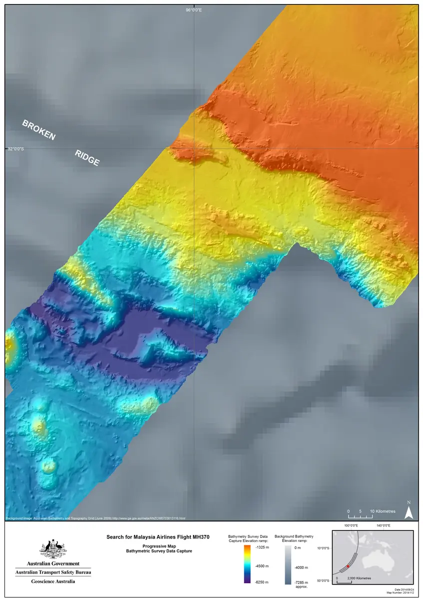
So the search began by mapping. From May 2014 the Chinese ship Zhu Kezhen and the Dutch firm Fugro's Fugro Equator, later helped by Fugro Supporter, crossed the search strip with multibeam echo sounders under the hull. By 2016 they had charted about 278,000 km² of seafloor in the search area, roughly the size of New Zealand, and hundreds of thousands more on their way to and from port. Geoscience Australia processed the data. The maps showed a landscape no one had seen: Broken Ridge and its escarpments falling more than 5,000 m, more than 150 seamounts and volcanoes, fault valleys over a kilometre deep and the scars of huge undersea landslides.
Guided by these maps, the underwater search began in October 2014. Ships towed sonar vehicles on cables up to 10 km long, close above the seafloor, and autonomous vehicles worked the steepest ground; analysts on board watched the sonar day and night, through two southern winters. By January 2017 they had searched 120,000 km² and checked hundreds of contacts. They found two nineteenth-century shipwrecks, which the Western Australian Museum later linked to the coal ships W. Gordon or Magdala and the West Ridge, a lost towfish that struck a mud volcano, and whale bones, but not the aircraft. Meanwhile, in July 2015, a wing flaperon from MH370 washed up on Réunion, and more debris followed on African shores. On 17 January 2017 Malaysia, Australia and China suspended the search.
The hunt did not stop there. The ATSB's final report of October 2017 judged that a smaller area further north along the arc was most likely. The company Ocean Infinity searched it in 2018 with a fleet of robot vehicles, and again in 2025 and early 2026 under a 'no find, no fee' contract with Malaysia; both times without a find. Ocean Infinity has now mapped more than 140,000 km² of its own. In June 2026 Malaysia extended its contract to 2027 to finish the last part of its zone. The cause of the loss can't be known until the aircraft is found.
The search left a scientific legacy. Australia made the data public in 2017 and 2018, and Ocean Infinity gave its 2018 data to the Seabed 2030 project, which aims to map the whole ocean floor. A strip of the remote Indian Ocean is now among the best-mapped deep seafloor on Earth, at a time when only about a tenth to a seventh of the ocean floor has been mapped by ships with this kind of sonar. The hunt for one aircraft made a map that geologists and oceanographers still use.
What happened
- 2014
Malaysia Airlines flight MH370, a Boeing 777 flying from Kuala Lumpur to Beijing with 239 passengers and crew, disappears from air traffic control radar. Satellite data later show it flew on for hours and ended its flight in the southern Indian Ocean.
Kuala Lumpur International Airport: where MH370 took off for Beijing on 8 March 2014The US Navy flies a towed pinger locator and other deep-sea search gear out of New York for the Indian Ocean, to listen for the pingers on the aircraft's flight recorders.
From the Australian ship Ocean Shield, the US Navy's Bluefin-21 underwater vehicle makes its first dive with side-scan sonar, near where acoustic signals were picked up early in April: the first look at the seabed itself.
The Chinese survey ship Zhu Kezhen leaves Fremantle to start mapping the seafloor of the search area, because the old maps, made mostly from satellites, are too coarse for sonar vehicles that must fly about 100 m above the bottom.
Fremantle Harbour: home port of the survey and search shipsBluefin-21 finishes its last mission after scanning about 850 km² of seafloor. Nothing is found, and the ATSB says the area of the April signals can be discounted as the aircraft's resting place.
Fugro Equator, under contract to the ATSB, begins the bathymetric survey with her hull-mounted multibeam echo sounder; she will map most of the area.
The ATSB publishes a new search area of up to 60,000 km² along the arc near Broken Ridge, the strip to be mapped and then searched.
The ATSB and Geoscience Australia publish the first detailed maps from the survey: ridges, fault valleys and seamounts appear where the old maps showed a blur.
Broken Ridge: the undersea plateau at the heart of the mapped search stripThe underwater search begins: GO Phoenix, contracted by Malaysia, starts sweeping the seafloor with a towed synthetic aperture sonar.
Fugro Discovery launches her towfish 'Dragon Prince' in the search area for the first time.
Fugro Equator stops survey work to be fitted out for the underwater search; the first season of mapping has charted about 208,000 km².
- 2015
Fugro Equator and Fugro Supporter join the underwater search; Supporter carries a HUGIN autonomous vehicle for the steep ground the towfish cannot cover.
Malaysia, Australia and China agree that if nothing is found in the 60,000 km² priority area the search will be doubled to 120,000 km².
Fugro's autonomous vehicle photographs scattered wreckage, an anchor and lumps of coal almost 4,000 m down: an uncharted nineteenth-century wooden ship, announced on 13 May. 'Not what we're looking for', said the search's director.
A wing part, the flaperon, washes up on the beach at Saint-André on Réunion, about 4,000 km west of the search area: the first physical trace of MH370. On 5 August Malaysia's prime minister says it is from the aircraft; on 3 September French prosecutors confirm it with certainty.
Saint-André, Réunion: where the flaperon washed ashore on 29 July 2015The ATSB publishes the Defence Science and Technology Group's analysis of where the aircraft most likely entered the sea, and maps the extended 120,000 km² area.
The search finds a second wreck, an iron sailing ship; Havila Harmony's autonomous vehicle images it in detail. The Western Australian Museum later names it as most likely the barque West Ridge, lost in 1883.
- 2016
Fugro Discovery's towfish strikes a mud volcano rising about 2,200 m from the seafloor; the cable snaps and the towfish and some 4,500 m of cable sink. It is later recovered.
An ATSB review of all the evidence concludes the aircraft is probably not in the searched area but may lie in about 25,000 km² further north along the arc; the governments decline to search it without new evidence.
The 25,000 km² area north of the searched zone that the ATSB judged most likely in December 2016- 2017
Fugro Equator leaves the search area as the last of the 120,000 km² is finished. Malaysia, Australia and China announce that the underwater search is suspended: MH370 'has not been located' in it.
Geoscience Australia's scientists describe the geology the survey revealed: more than 150 seamounts and knolls, an escarpment falling more than 5,100 m, and landslide scars 180 m high with debris fans over 150 km long.
Geoscience Australia releases the first phase of the seafloor data to the public, with an interactive story map: one of the most thoroughly mapped regions of the deep ocean on Earth.
The ATSB publishes its final report, 'The Operational Search for MH370', 440 pages long: the search has eliminated most of the high-probability areas, but the aircraft has not been found.
- 2018
The private company Ocean Infinity begins a new search on a 'no find, no fee' contract with Malaysia, sending a fleet of autonomous underwater vehicles from the ship Seabed Constructor into the area north of the old search.
The Western Australian Museum reports on the two wrecks the search found, 36 km apart and more than 3.7 km deep: the deepest wrecks yet located in the Indian Ocean.
Ocean Infinity's 2018 search ends without finding the aircraft; its seafloor data go to the Nippon Foundation–GEBCO Seabed 2030 project for the global ocean map.
Geoscience Australia releases the second phase: the sonar data of the underwater search, which showed whale bones, geological features and the remains of several shipwrecks.
- 2025
Malaysia's transport minister Anthony Loke says Ocean Infinity has started searching again, in a new area of 15,000 km², before its contract is signed.
Malaysia gives final approval to the 'no find, no fee' deal: Ocean Infinity will be paid US$70 million only if the wreckage is found.
Ocean Infinity pauses the search for the southern winter; Loke says it is 'not the season'.
The search resumes for a planned 55 days at sea in a targeted area of the southern Indian Ocean.
- 2026
Ocean Infinity's vessel leaves the search area. In the two phases since 2025 it has covered about 7,571 km² of the 15,000 km² zone.
On the twelfth anniversary Ocean Infinity announces that this phase has ended without a find, after 151 days at sea since 2018 and more than 140,000 km² of seafloor mapped. 'It isn't where we looked,' says its chief executive.
Malaysia extends the contract by a year, to 30 June 2027, to finish the remaining 7,428.54 km²; the ships are away on other work until about April 2027.