Google Maps and Google Earth launch
“Google turned two 2004 purchases, Where 2 and Keyhole, into Google Maps (8 February 2005) and Google Earth (28 June 2005): free, fast maps and a satellite globe that soon fitted in every pocket.”
Google Maps and Google Earth were built from two small companies that Google bought in 2004. Where 2 Technologies, in Sydney, was started by the Danish brothers Lars and Jens Rasmussen with Noel Gordon and Stephen Ma. Their mapping program ran on the user's own computer, and Google had them rebuild it as a web page. On 27 October 2004 Google also announced that it had bought Keyhole, a Mountain View company whose software let a user fly from a view of space down to a street corner, using a large database of satellite and aerial images with roads and businesses on top. The price was not made public in either case.
Google Maps opened on 8 February 2005. Its first post on the Google Blog, by product manager Bret Taylor, stressed two things: a clear new map that you could drag around with no wait for a new picture to load, and step-by-step directions that you could click to zoom in on a tricky turn. On 4 April 2005 a 'Satellite' button added Keyhole's images, and on 28 June 2005 Keyhole's program came back as Google Earth, with 3D models of the biggest US cities, a search of Google Local from inside the globe, and a free version. The next day Google released the Maps API, so that anyone could put a Google map on their own website, and sites such as housingmaps.com, which put house listings on the map, appeared.
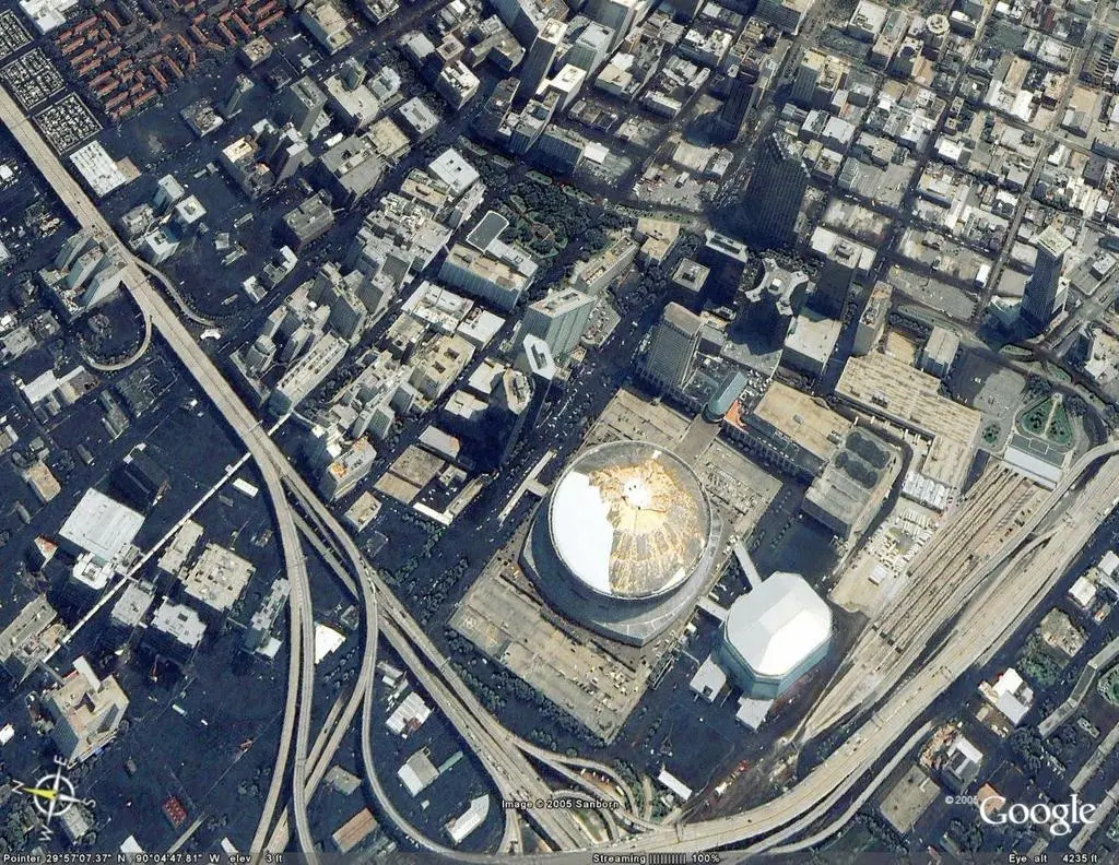
Within months the tools showed what they were for. After Hurricane Katrina struck in August 2005 (the National Hurricane Center says about 80 percent of New Orleans flooded), Google Maps put up new satellite pictures of the city on 2 September, and Google Earth users made more than 100 'before and after' overlays in a day. In January 2007 the first iPhone shipped with Google Maps, and on 29 May 2007 Street View added photographs taken at street level. Maps came to Android phones in 2008, got spoken turn-by-turn navigation on 28 October 2009, and in June 2013 Google closed its purchase of the traffic app Waze. In February 2020 Google said more than a billion people use Maps every month.
Earth kept changing too. A new Earth for the web and Android arrived on 18 April 2017 with 'Voyager', a set of guided tours. On 15 April 2021 Timelapse added about 24 million satellite images from 1984 to 2020, so that any place could be watched changing year by year. Google's Maps API draws the flat map in the Mercator projection, which Gerardus Mercator designed for sailors in 1569, and cuts the map off near 85 degrees of latitude. The desktop program Google Earth Pro will not be available for download after 25 June 2027, Google says; the web and phone versions carry on. Between them, two bought-in start-ups turned the map from a sheet of paper into a service that most people check every day.
What happened
- 2004
Where 2 Technologies, a Sydney start-up, joins Google; its map program is rebuilt as a web page. Most accounts say October 2004.
Sydney, Australia: where Where 2 Technologies was started in 2003 by Lars and Jens Rasmussen, Noel Gordon and Stephen MaGoogle announces that it has bought Keyhole, a Mountain View mapping company; it cuts the price of Keyhole 2 LT from $69.95 to $29.95 at once.
The Googleplex, Mountain View, California: Google's headquarters, and Keyhole's town, where Maps and Earth were built after the 2004 purchases- 2005
Google Maps opens, announced on the Google Blog by product manager Bret Taylor: a clear map you can drag, and step-by-step directions.
The Googleplex, Mountain View, California: Google's headquarters, and Keyhole's town, where Maps and Earth were built after the 2004 purchasesA 'Satellite' link adds Keyhole's pictures to Google Maps and Google Local; the first hint of what Earth would be.
Google Earth is released, built on Keyhole's program, with 3D city models, Google Local search and a free version.
The Googleplex, Mountain View, California: Google's headquarters, and Keyhole's town, where Maps and Earth were built after the 2004 purchasesThe Google Maps API lets anyone put a Google map on a web page; housingmaps.com and chicagocrime.org are the first examples named.
Hurricane Katrina makes landfall near Buras, Louisiana, at 11:10 UTC as a Category 3 hurricane; the levees around New Orleans fail and about 80 percent of the city floods.
New Orleans, Louisiana: the city whose flooded streets Google Maps and Earth showed within days of Hurricane Katrina in September 2005Google Maps puts up satellite images of New Orleans taken on Wednesday 31 August, behind a red 'Katrina' button.
New Orleans, Louisiana: the city whose flooded streets Google Maps and Earth showed within days of Hurricane Katrina in September 2005Google Earth users have made more than 100 overlays in 24 hours; a slider moves between 'before' and 'after' pictures of places such as the Superdome.
New Orleans, Louisiana: the city whose flooded streets Google Maps and Earth showed within days of Hurricane Katrina in September 2005Google Local for mobile puts listings, maps and aerial views on Java phones.
- 2007
Apple shows the iPhone at Macworld in San Francisco; its press release says it 'includes Google Maps'.
Moscone Center, San Francisco (the iPhone keynote was in Moscone West): Macworld, where Apple showed the first iPhone with Google Maps on 9 January 2007Street View opens, with photographs taken at street level in a handful of US cities.
Sky in Google Earth lets users look at the stars; the astronaut Sally Ride writes about it on the Google Blog.
- 2008
The T-Mobile G1, the first Android phone, is launched with Google Maps on it.
- 2009
Google Maps Navigation (beta) for Android 2.0 brings 3D views, spoken turn-by-turn directions and automatic rerouting.
- 2010
Google Earth Engine launches as a Google Labs product at the UN climate conference in Cancun, a catalogue of satellite imagery for tracking changes such as deforestation.
- 2013
Google closes its purchase of Waze, the traffic app run by its drivers, whose team stays in Israel.
- 2017
A new Google Earth opens on the web and Android, with Voyager, more than 50 guided stories at launch.
- 2020
For Maps' 15th birthday Google says more than a billion people use it every month.
- 2021
Timelapse in Google Earth shows about 24 million satellite images from 1984 to 2020 as a moving picture of the whole planet.
- 2026
Google says that from 25 June 2027 the desktop program Google Earth Pro can no longer be downloaded; installed copies keep working.