Landsat starts photographing the Earth from space
“On 23 July 1972 NASA launched ERTS-1, later Landsat 1, and began a record of the Earth's land from space that has now run for more than fifty years.”
On 23 July 1972 a Delta rocket lifted the Earth Resources Technology Satellite, ERTS-A, from Vandenberg Air Force Base in California. In orbit it became ERTS-1; in January 1975 NASA renamed it Landsat 1, because a sister ship called Seasat was planned for the oceans and 'Landsat' suited the satellite that watched the land. It circled the Earth about fourteen times a day at 917 km, on a near-polar path timed to pass over each place at about 9:30 in the morning, and it came back to the same ground every 18 days. Two instruments were aboard. Three television-like cameras, the Return Beam Vidicon, were meant to be the main tool. A scanner with a swinging mirror, the Multispectral Scanner, was the experimental extra: it recorded four colour bands, including two in the invisible near-infrared, with pixels about 80 metres wide. After a fault in the cameras in the first weeks, the scanner became the star.
The idea came from Washington, not from space engineers. In the early 1960s geologists at the U.S. Geological Survey, led by its director William Pecora, and farm experts at the Department of Agriculture saw what astronauts' photographs and aircraft surveys could show of the land, and they wanted a regular, repeating view. On 21 September 1966 Interior Secretary Stewart Udall announced Project EROS, an Interior Department satellite plan. NASA protested but took the hint: it began studies for its own satellite in 1967 and the project was approved by early 1969. The new satellite used a spacecraft built for the Nimbus weather satellites. Its promise was simple. One account notes that about 30,000 aircraft photographs would be needed to cover the United States, while a single satellite could do it with fewer than 600 images; in 1974 the Department of Agriculture's map-makers did just that, joining 595 of its scenes into a ten-by-sixteen-foot mosaic of the lower 48 states, the map that stands for this entry.
Its first picture, on 25 July 1972, was of the Dallas-Fort Worth area; within days it recorded a burning forest in Alaska, the glaciers of the Wrangell Mountains, and then the world. Because it saw the same ground again and again, with the same sun angle, it could show change. Landsat 1 showed clear-cutting in Oregon, the spread of floods on the Mississippi in 1973, and a Mount St. Helens that no one yet knew would blow up in 1980. It was switched off on 6 January 1978, long after its one-year design life, having imaged about three-quarters of the Earth's surface. Landsat 2 (1975) and 3 (1978) followed, then Landsat 4 (1982) and 5 (1984) with a Thematic Mapper that had seven bands, 30 metre pixels and, for the first time, a blue band for natural-colour pictures. Landsat 5 worked for almost 29 years, the longest of any Earth-observing satellite. Landsat 6 was lost at launch in 1993, Landsat 7 flew from 1999 to 2025, Landsat 8 was launched in 2013 and Landsat 9 in September 2021.
What the project changed was less the cameras than the idea that the planet could be measured the same way, year after year. Landsat was handed to a private firm, EOSAT, in 1985 and back to the government in 1992; in those years a single Thematic Mapper scene cost about $4,000. In January 2008 the heads of USGS and NASA's Earth science division signed a policy to give all the data away, announced on 21 April 2008, and daily downloads from the archive at the USGS EROS Center near Sioux Falls rose from 53 scenes to more than 5,700. The same archive now shows forests lost, cities grown, glaciers retreating and lakes drying across more than fifty years. In 2011 UNESCO put the early scanner data on its Memory of the World register.
What happened
- 1966
At a press event in Washington, Interior Secretary Stewart Udall announces Project EROS, the Earth Resources Observation Satellites, a plan to gather facts about the planet's natural resources from orbit. USGS director William Pecora had persuaded him, and the announcement is partly a signal to NASA that Interior wants its own satellites. NASA's account says Udall was on a rafting trip at the time; USGS speaks of his press conference (see qa).
The Department of the Interior's main building in Washington, where Stewart Udall announced Project EROS- 1967
NASA starts definition studies for the satellite, now called ERTS (Earth Resources Technology Satellite), after the 1964-66 joint studies with Interior and Agriculture.
NASA's Goddard Space Flight Center in Greenbelt, Maryland, home of the Landsat project and of its first ground reception - 1969
The ERTS project is approved, with two satellites, ERTS-A and ERTS-B, planned.
- 1971
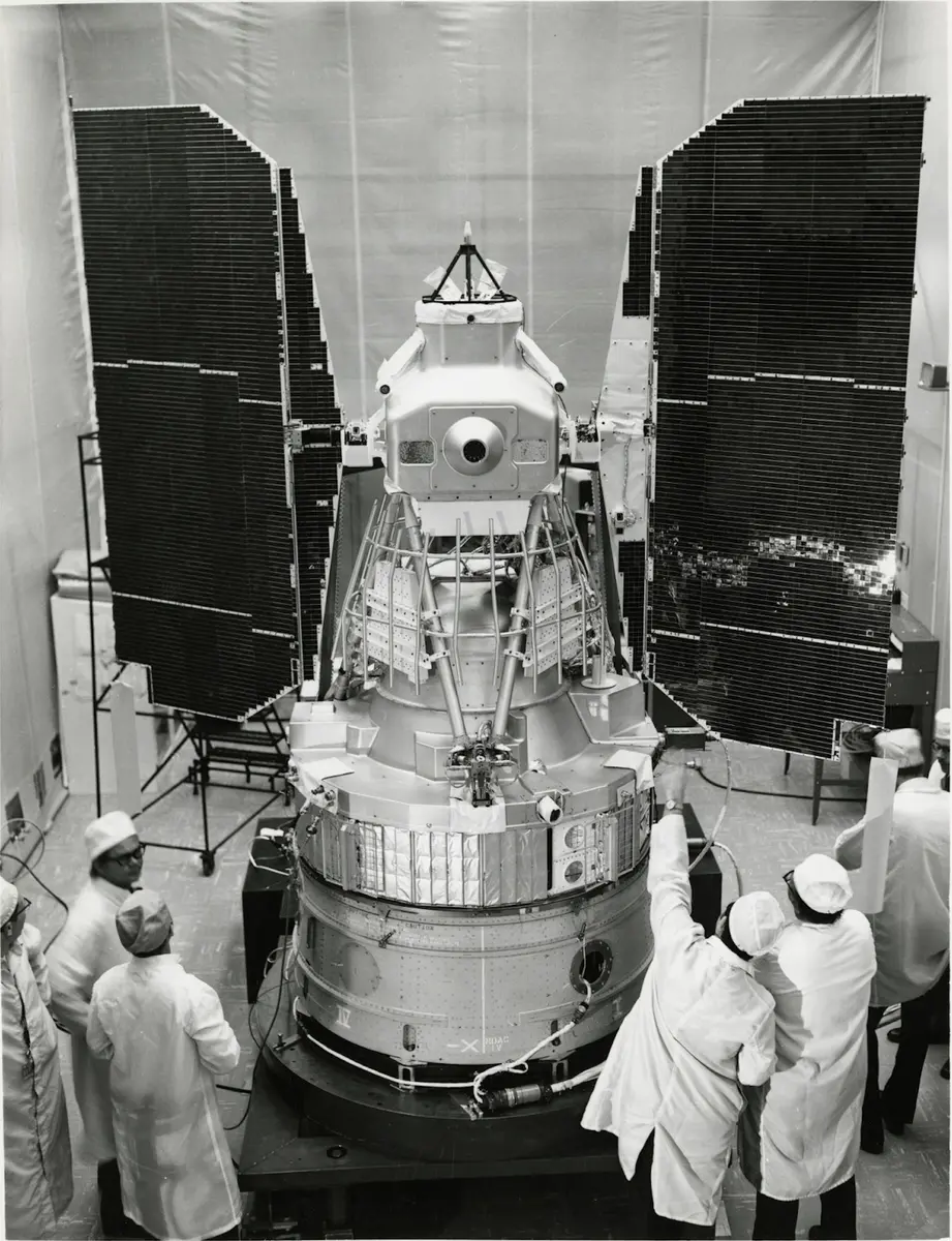
The full-size mock-up of ERTS stands in a space chamber at General Electric's Space Division, thirteen months before launch (NASA image 71-HC-973).
- 1972
William Pecora, the Interior Under Secretary who had pressed for the satellite, dies a few days before it flies.
ERTS-A is launched on a Delta rocket from Vandenberg Air Force Base in California and becomes ERTS-1 in orbit. It circles at about 917 km on a near-polar, sun-synchronous path and returns to the same ground every 18 days.
Vandenberg Space Launch Complex 2, where ERTS-1 lifted off on a Delta rocket on 23 July 1972The scanner sends its first image, of the Dallas-Fort Worth area. USGS calls it the first in the Landsat archive.
Dallas-Fort Worth, Texas, the area in the first Landsat 1 imageA week after launch, ERTS-1 images the glaciers of Alaska's Wrangell-St. Elias region, one of the first views of the world's ice from space.
Wrangell-St. Elias National Park, Alaska, where Landsat 1 first looked at glaciersThe Return Beam Vidicon, planned as the main instrument, is shut down after an electrical fault disturbs the satellite's attitude control. The experimental Multispectral Scanner becomes the instrument that makes ERTS-1 famous. Wikipedia, citing eoPortal, gives 5 August; USGS gives no date.
- 1973
Landsat 1 photographs the Mississippi flood around the Morganza Spillway in Louisiana, showing the floodwater across the lowlands.
Morganza Spillway, Louisiana, in the 1973 Mississippi flood- 1974
NASA photographs the first satellite photomosaic of the lower 48 states: 595 cloud-free ERTS-1 images in a map ten by sixteen feet, built by the U.S. Department of Agriculture's Soil Conservation Service. The date is the one NASA gives for the photograph.
- 1975
NASA announces that ERTS-1 is now Landsat 1 and that ERTS-B will be Landsat 2, because the planned Seasat would watch the oceans and 'Landsat' suited the satellite that watched the land.
Landsat 2 is launched on a Delta 2910 from Vandenberg. It flies for seven years and is decommissioned on 27 July 1983.
- 1978
Landsat 1 is turned off, after outliving its one-year design life by five years. It had imaged about three-quarters of the Earth's surface.
Landsat 3 is launched, with improved cameras and a thermal band that fails soon after. Two satellites in orbit allow nine-day repeat coverage of the United States.
Vandenberg Space Launch Complex 2, where ERTS-1 lifted off on a Delta rocket on 23 July 1972- 1982
Landsat 4 is launched on a Delta 3920. It carries the new Thematic Mapper, with seven bands and 30 m pixels, in an orbit at 705 km that repeats every 16 days.
Landsat 4's first light image, near Detroit and western Lake Erie, is the first in the programme in natural colour.
- 1984
Landsat 5 is launched from Vandenberg. It will work for almost 29 years and enter the Guinness records as the longest-operating Earth-observation satellite.
- 1985
The U.S. government transfers Landsat to a private firm, the Earth Observation Satellite Company (EOSAT). Scenes rise in price: a Thematic Mapper image cost $4,000 in 1995.
- 1986
Landsat 5 images show the damage at the Chernobyl nuclear plant after the accident of 26 April 1986, the first confirmation from a civilian satellite.
- 1992
The U.S. government takes the Landsat programme back under its own control.
- 1993
Landsat 6 fails to reach orbit.
- 1999
Landsat 7 is launched on a Delta II from Vandenberg.
- 2003
The scan line corrector of Landsat 7 fails for good; later images carry stripes of missing data.
- 2008
USGS announces that Landsat images will be free. The policy was signed in January 2008 by Barb Ryan of USGS and Michael Freilich of NASA. Daily scene downloads rise from 53 to 5,775.
USGS EROS Center near Sioux Falls, South Dakota, which keeps the Landsat archive- 2011
UNESCO's Memory of the World programme adds the Landsat Multispectral Scanner datasets to its register.
- 2013
Landsat 8, launched as the Landsat Data Continuity Mission on an Atlas V, is renamed Landsat 8 on 30 May.
Landsat 5 is decommissioned after more than 150,000 orbits and 2.5 million images.
- 2021
Landsat 9 is launched on an Atlas V from Vandenberg. It orbits eight days apart from Landsat 8, so the pair see every place every eight days.
Vandenberg Space Launch Complex 2, where ERTS-1 lifted off on a Delta rocket on 23 July 1972- 2025
Landsat 7 is decommissioned after 26 years; it stopped collecting science data on 19 January 2024.