Waldseemüller's map names America
“In 1507 scholars in a small Lorraine town printed a twelve-sheet world map that put the name America on the New World, after Amerigo Vespucci; one copy survives.”
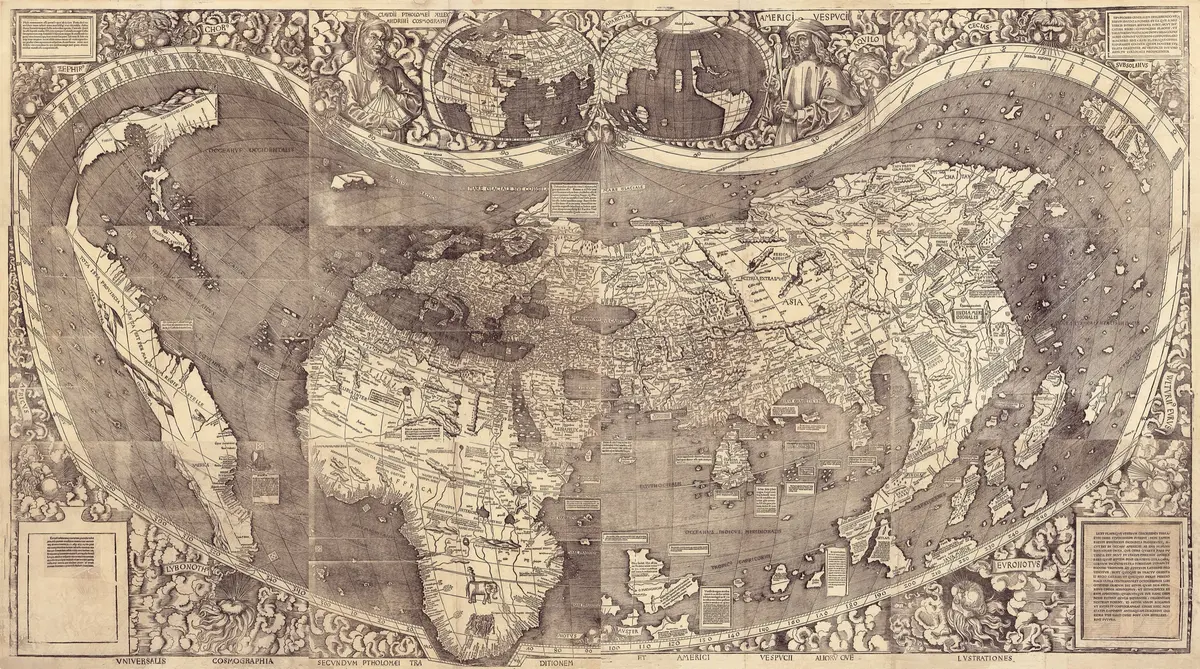
In 1507, in Saint-Dié, a small town in the Vosges mountains of Lorraine, a group of scholars printed a world map on twelve sheets of paper, each cut from its own block of wood. Pasted together, the sheets made a wall map more than four feet by eight. On the southern half of the New World it carried a word that had never been printed on a map before: AMERICA. A little book printed beside it, the Cosmographiae Introductio, explained where the word came from.
The people behind it called themselves the Gymnasium Vosagense. Gautier Lud, head of the canons of Saint-Dié and secretary to Duke René II of Lorraine, had set up a printing press in his nephew's house and gathered scholars around it: the poet Matthias Ringmann, the translator Jean Basin, and the mapmaker Martin Waldseemüller. Their big plan was a new edition of Ptolemy's Geography, the ancient guide to the world. Then news from Spain and Portugal made the old picture look out of date. Lud got hold of a French account of the voyages of Amerigo Vespucci, a Florentine who had sailed along the coast of South America, and Basin put it into Latin. Vespucci wrote of a 'new world', and the scholars took him for its discoverer.
The book, finished on 25 April 1507, said it plainly: the fourth part of the world should be called Amerige, 'the land of Americus', or America, since Europe and Asia had both been named after women. The map and a set of globe gores, printed segments to be pasted onto a small ball, did the naming in pictures. The map shows the New World as a land of its own, surrounded by water and separated from Asia by an ocean on its far side. Europeans would not see that ocean from the American side until Balboa climbed a peak in Panama in 1513, so historians still ask how much Waldseemüller knew and how much he guessed. Vespucci was still alive; he died in 1512.
About a thousand copies of the map are said to have been printed, and the name caught on at once. Yet Waldseemüller himself let it go. In his Ptolemy of 1513 the land is just 'Terra Incognita', and on his big sea chart of 1516 he drew the northern part as a piece of Asia and left the name off altogether. Others kept it alive: Johannes Schöner put AMERICA on a globe in 1515, Peter Apian on a map in 1520, and after that it was hard to undo.
Only one copy of the wall map is known to survive. Schöner had kept it in a portfolio, and it lay unseen in Wolfegg Castle in Germany until the Jesuit scholar Joseph Fischer found it, around 1901. The Library of Congress agreed to buy it in 2001 for ten million dollars and finished paying in 2003; on 30 April 2007, five hundred years after it was printed, Chancellor Angela Merkel formally handed it over to the American people. It is often called America's birth certificate.
What happened
- 1507
In the little Lorraine town of Saint-Dié a circle of scholars works under the protection of Duke René II, whose secretary and chaplain, Gautier Lud, heads the town's canons. They call themselves the Gymnasium Vosagense.
Saint-Dié: the Vosges town where Gautier Lud's press and the Gymnasium Vosagense printed the map and the bookLud has set up a printing press in the house of his nephew Nicolas. Its first great project is a new Ptolemy; Ringmann edits, Basin translates and Waldseemüller draws.
Saint-Dié: the Vosges town where Gautier Lud's press and the Gymnasium Vosagense printed the map and the bookThe plan is to redo Ptolemy's Geography, the old picture of the world, in the light of the new voyages; the map's own title promises Ptolemy's tradition together with the voyages of Amerigo Vespucci and others.
Lud gets a French account of Vespucci's four voyages from Portugal, and Basin puts it into Latin; the scholars take Vespucci for the discoverer of a new world. They also have charts of the new coasts from Portuguese and Spanish sources.
The wall map itself, twelve woodcut sheets, appears in the spring: the word AMERICA stands on the southern land. No author, date or place is printed on it. About a thousand copies are said to have been struck.
Saint-Dié: the Vosges town where Gautier Lud's press and the Gymnasium Vosagense printed the map and the bookVespucci's portrait sits at the top of the map beside a small inset world map in which the New World is a land of its own, with sea around it.
The globe gores are printed from a single block, to be cut out and pasted on a ball; they carry the name too, and were issued with the book. Of that printing only three copies are known.
The Cosmographiae Introductio comes off the press, bound with the Four Voyages of Vespucci and dedicated to the Emperor Maximilian I. It proposes calling the fourth part of the world 'Amerige', land of Americus, or America, as Europe and Asia took women's names.
Saint-Dié: the Vosges town where Gautier Lud's press and the Gymnasium Vosagense printed the map and the bookA second printing of the Cosmographiae Introductio follows on 29 August: within months several editions of the text are in circulation.
- 1513
In the Ptolemy printed at Strasbourg by Johann Schott, with Waldseemüller's maps, the land named America in 1507 is labelled 'Terra Incognita'; the name is gone.
Strasbourg: where Ringmann and Waldseemüller studied Ptolemy's maps and where the 1513 Ptolemy, without the name America, was printedIn late September Vasco Núñez de Balboa climbs a peak on the Isthmus of Panama and sees the Pacific, the first European known to have seen the ocean that the 1507 map already drew beyond the New World.
- 1515
Johannes Schöner makes a globe on which AMERICA is written on the southern New World; the Library of Congress names Schöner's 1515 work among the first to adopt it.
- 1516
Waldseemüller's big sea chart, the Carta Marina, calls the southern land 'Terra Nova' and the northern one Cuba, part of Asia; the name America appears nowhere, and the chart owes much to the Cantino map.
- 1520
Peter Apian's world map takes up the name again, under a title that echoes Waldseemüller's. From here on the name stays on maps of the New World.